As the prevalence and volume of geospatial data increases, so does the value of insights associated with gaining an understanding of ‘space’ by effectively collecting, managing, and analyzing the various spatial data sources. Geospatial Information Systems (GIS) have become a common tool utilized by public agencies and the private sector to guide and inform its decision-making process.
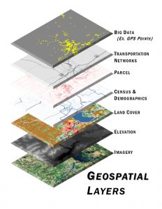
Quetica utilizes GIS to assist its clients with data collection and the inventorying of assets, spatial analysis, data visualization, and cartography. It is a key tool in understanding location, associated transport costs, and the impacts on moving raw commodities, intermediate goods, and finished products. These insights are the foundation when assisting private sector companies design supply chains through the optimal siting of manufacturing plants and distribution facilities. In addition, it is used to help public agencies identify beneficial multimodal infrastructure investments and market regions for new development.
GIS processes are also used to normalize non-spatially related data and inform algorithms within our ITS Solutions. GIS is integrated into our engineering practices’ allowing for project plans, drawings, and 3-D models to be properly located within the real-world.